CITIES AND MUNICIPALITIES OF CAGAYAN
Cagayan Province, located in the northeastern part of Luzon, Philippines, boasts stunning natural beauty. It encompasses the Babuyan Islands to the north and shares borders with Ilocos Norte, Apayao, Kalinga, and Isabela. The capital city is Tuguegarao. The province consists of one city which is Tuguegarao and 28 municipalities. Historically, Cagayan was one of the early Spanish colonial provinces, known as “La Provincia de Cagayan.” The name “Cagayan” is believed to have originated from the word “tagay,” referring to a plant that grows abundantly in the region. The province’s economy thrives on agriculture, fishing, and tourism, with attractions like Callao Caves, Palaui Island, and the Babuyan Islands drawing visitors.
These are the cities and municipalities of Cagayan:
CITIES:
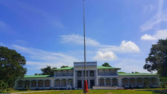
TUGUEGARAO CITY
Tuguegarao City, the capital of Cagayan Province in the Philippines, holds historical significance. Its name is believed to mean “this was cleared by fire.” The city’s economy thrives on agriculture, fisheries, and tourism. Landmarks include the St. Peter Metropolitan Cathedral and the Buntun Bridge.
Visit the official website and Facebook page of Tuguegarao City:

MUNICIPALITIES:
- Abulug
- Alcala
- Allacapan
- Amulung
- Aparri
- Baggao
- Ballesteros
- Buguey
- Calayan
- Camalanuigan
- Claveria
- Enrile
- Gattaran
- Gonzaga
- Iguig
- Lal-lo
- Lasam
- Pamplona
- Penablanca
- Piat
- Rizal
- Sanchez-Mira
- Santa Ana
- Santa Praxedes
- Santa Teresita
- Santo Nino
- Solana
- Tuao
ABULUG
The municipality of Abulug lies between the municipalities of Ballesteros and Pamplona on the Northwestern part of Cagayan along the China Sea. It is a typical Ybanag town. The immigrating Ilocanos had contributed to a large extent to the progress of the town.
It’s important agricultural products are rice, vegetables and industrial products are lumber and fish. Its native craft, cottage and trade are mat-weaving, pottery, nipa shingle and native winemaking. Favored with many attractions, the majestic bend of its namesake river, immensely fertile agricultural areas, unspoiled back-country scenes and friendly people.
Visit the official Facebook page of Abulug:
ALCALA
Alcala is home to the Saint Philomene Church, regarded as the widest church in the Cagayan Valley. Notably, it is the birthplace of Senator Melecio Arranz of the 1st Senatorial District of the Philippines. Geographically, Alcala is 35 kilometers (22 miles) from Tuguegarao and 516 kilometers (321 miles) from Manila.
The indigenous tribes of the Ibanag people were the first settlers of modern-day Alcala. They called the area Fulay, which literally means “red,” referring to the distinct red color of its soil. After two centuries of Spanish rule, Fulay was formally proclaimed as a township on July 20, 1789. However, it was not until 1843 when it was renamed Alcala, in honor of the governor general Francisco Paula de Alcala.
Visit the official Facebook page of Alcala:

ALLACAPAN
Allacapan is situated in the north-western periphery of Cagayan, bordering Apayao. It is approximately 93 kilometers (58 miles) from Tuguegarao and about 574 kilometers (357 miles) from Manila.
Visit the official website and Facebook page of Allacapan:
AMULUNG
The name Amulung is derived from the fruit tree Goniothalamus amuyon (also known as amuyon or amuyong in Ilocano). Additionally, Fr. Jose Bugarin’s dictionary defines amulung as “a type of vine, with fig-like leaves, well used for reducing swelling/inflammation”.
Formerly administered from Iguig, Amulung was formally established on May 10, 1734, by the Spaniards as a stopover along the Cagayan River.
Visit the official Facebook page of Amulung:
APARRI
Nestled in a river delta and facing the coast of Babuyan Channel, Aparri is the gateway to the Northern Philippines. International trade took place in the town in the 14th century with our Chinese and Japanese neighbors. Aparri is also famous for its aramang, surfing spots, rich culture, and amiable people. Aparri holds historical significance due to its coastal location at the mouth of the Cagayan River. The town’s economy primarily relies on fishing, agriculture, and trade. As a gateway to the Babuyan Islands, Aparri plays a crucial role in maritime activities. Tourists are drawn to its scenic beaches, and the Cagayan North International Airport (also known as Lal-lo Airport) serves the region.
Visit the official Facebook page of Appari:
BAGGAO
Baggao is a picturesque coastal municipality situated in the province of Cagayan, Philippines. Nestled along the coast, it boasts a population of approximately 87,753 residents across 48 barangays. Covering an area of 995.49 square kilometers (about 384.36 square miles), Baggao is a vibrant community that offers both natural beauty and cultural richness.
Visit the official website and Facebook page of Baggao:
BALLESTEROS
Ballesteros is a municipality in the province of Cagayan, Philippines, known for its scenic beauty and rich cultural heritage. Nestled along the northeastern coast of Luzon, it boasts stunning beaches, lush greenery, and a laid-back atmosphere. The town is also famous for its annual fiesta celebrations, where locals and visitors alike come together to enjoy traditional food, music, and dance. Ballesteros offers a serene escape for those seeking to immerse themselves in nature and experience the warmth of Filipino hospitality.
Visit the official Facebook page of Ballesteros:

BUGUEY
Buguey, Cagayan, located along the northeastern coast of Luzon, is a coastal municipality renowned for its pristine beaches and abundant marine life. The town’s coastline stretches along the Babuyan Channel, offering breathtaking views of the Pacific Ocean. Buguey is also celebrated for its rich fishing grounds, providing livelihoods for many of its residents. With its picturesque shores and thriving fishing industry, Buguey beckons travelers seeking tranquility and a taste of coastal living in the Philippines.
Visit the official Facebook page of Buguey:
CALAYAN
Calayan is a remote island municipality located in the Babuyan Group of Islands in the province of Cagayan, Philippines. It is known for its stunning natural beauty, including pristine beaches, crystal-clear waters, and rugged cliffs. The island is a haven for adventurers and nature lovers, offering opportunities for activities such as diving, snorkeling, and hiking. Calayan is also rich in marine biodiversity, making it a popular destination for marine enthusiasts. Despite its remoteness, the warmth and hospitality of the locals make visitors feel welcome, adding to the charm of this hidden gem in the Philippines.
Visit the Facebook page of Calayan:

CAMALANUIGAN
Camalaniugan, a municipality in the province of Cagayan, Philippines, is steeped in history, having been founded on June 15, 1596, due to its proximity to Nueva Segovia (Lallo). It is renowned for housing the oldest Christian bell in the Far East, located in the church of San Jacinto de Polonia, a testament to its rich religious heritage. The town’s name is derived from the “malaniug” trees, once abundant in the area, reflecting its deep connection to nature and the environment. Camalaniugan’s cultural landscape is further enriched by its well-preserved Spanish horno, the most intact in the country, showcasing its historical significance.
Visit the official website and Facebook page of Camalanuigan:
CLAVERIA
Claveria, a coastal municipality in Cagayan, is a historical gem that was officially established as a Spanish mission called Cabicungan on April 17, 1633. It was renamed in the 19th century after the Spanish Governor-General Narciso Clavería, following its establishment as a civil town on March 9, 1865. The town is adorned with natural attractions such as the Claveria Viewdeck, Taggat Lagoon, and Sentinela Cove, offering panoramic views and serene beach escapes. Claveria’s cultural fabric is woven with the traditions of the Ibanag people, and it’s celebrated for its exquisite beauty and tranquil coastal life.
Visit the official website and Facebook page of Claveria:

ENRILE
Considered the Peanut Capital of Northern Philippines, Enrile is more than inspired to open its natural wonders for everyone’s taking. It is situated in the Cagayan Valley region of the Philippines, is a municipality with a rich agricultural heritage. Its fertile lands support the cultivation of various crops, contributing significantly to the local economy. Enrile is also known for its cultural festivities, including the celebration of the feast day of its patron saint, St. Isidore the Farmer. With its friendly community and scenic surroundings, Enrile offers visitors a glimpse into rural Filipino life and a warm welcome to all who venture into its midst.
Visit the official website and Facebook page of Enrile:

GATTARAN
Gattaran is a coastal municipality in the province of Cagayan, Philippines. It covers approximately 707.50 square kilometers (273.17 square miles) and is situated along the Philippine Sea. The municipality is divided into 50 barangays, including Aguiguican, Baracaoit, Basao, Dummun, Mabuno, and San Vicente. Visitors can explore historic spots and tourist landmarks, such as the Cagayan Forest and Eco Tourism Park in Nassiping. Enjoy discovering the rich culture and natural beauty of this beautiful coastal area.
Visit the official Facebook page of Gattaran:
GONZAGA
Gonzaga is situated at the north-eastern tip of the province of Cagayan. It shares borders with the municipalities of Santa Ana (to the north-east), Santa Teresita (to the west), and Lal-lo (to the south). The town’s natural resources include cream, black, and rocky beaches, protected coral reefs, and the imposing Mt. Cagua. These attractions make Gonzaga a favorite destination for adventure travelers.
Visit the official Facebook page of Gonzaga:
IGUIG
Iguig, officially known as the Municipality of Iguig, is a 4th class municipality located in the province of Cagayan, Philippines.With abundant red clay soil and artisanal pottery makers, Iguig has been known as the “Pottery Center of Cagayan.” It is also known for its deep Catholic faith, larger-than-life expression of the Passion of Christ, and remarkable architecture.
Geographically, Iguig lies 14 kilometers (8.7 miles) away from Tuguegarao and 495 kilometers (308 miles) from Manila. The town was officially established as a Spanish mission on April 16, 1608. The name “Iguig” is said to mean “the place of Ig”, referring to a native chieftain and warrior who once lived in the area.
Visit the official Facebook page of Iguig:

LAL-LO
Lal-lo is a first-class municipality along the Cagayan River, known historically as Ciudad de Nueva Segovia. Efforts are underway to regain its Spanish-era city status. Lal-lo hosts the Cagayan North International Airport, accommodating large aircraft. The name “Lal-lo” means “twisting two strands to make a rope,” possibly referring to the strong river current along the Cagayan River.
Visit the official Facebook page of Lal-lo:
LASAM
Lasam was previously part of the Gattaran Municipality, separated by the wide Cagayan River without any connecting bridges. On June 13, 1950, Republic Act No. 507 officially established Lasam as an independent municipality, signed by President Elpidio Quirino. The old site of Barrio Macatabang became the seat of the government for the new town. Ignacio Jurado served as the first mayor, tasked with building the infrastructure for the newly independent Lasam.

PAMPLONA
Pamplona is another municipality located in the province of Cagayan, Philippines. It is known for its agricultural industry, particularly rice cultivation, which thrives in its fertile lands. The town is also rich in natural resources, with picturesque landscapes that include rivers, hills, and forests, making it a potential eco-tourism destination. Pamplona is home to a vibrant community that celebrates its cultural heritage through various festivals and events throughout the year. With its tranquil surroundings and warm-hearted locals, Pamplona offers a glimpse into the charm of rural life in the Philippines.
Visit the official Facebook page of Pamplona:
PEÑABLANCA
Peñablanca is a 1st class municipality located in the province of Cagayan, Philippines. Notable features include the Callao Cave, which is part of the Callao Limestone Formation Paleolithic Archaeological Site, and the Peñablanca petrographs. The municipality was formerly a barrio of Tuguegarao and was named after its prominent white rock formations.
Visit the official Facebook page of Peñablanca:
PIAT
Piat, Cagayan, located in the northern part of the Philippines, is a town steeped in history and culture. Famous for its religious significance, it draws pilgrims from across the country to the Basilica Minore of Our Lady of Piat, where the revered Black Virgin Mary is enshrined. Beyond its spiritual allure, Piat boasts picturesque landscapes, with rolling hills and lush greenery that make it a charming destination for nature lovers. Its vibrant local market, bustling with activity, offers a glimpse into the town’s dynamic community and traditional way of life. Piat Cagayan stands as a testament to the rich tapestry of Philippine heritage and continues to captivate visitors with its blend of spirituality, natural beauty, and cultural heritage.
Visit the official website and Facebook page of Piat:
RIZAL
Rizal is a municipality in the province of Cagayan, Philippines, situated in the northeastern part of Luzon. It is known for its agricultural industry, with rice and corn being the primary crops grown in the area. The town is also home to picturesque landscapes, including rolling hills and verdant valleys, making it a scenic destination for nature enthusiasts. Rizal celebrates its cultural heritage through various festivals and events, showcasing traditional music, dance, and cuisine. With its tranquil ambiance and friendly locals, Rizal offers visitors a glimpse into the rural charm of the Philippines.
Visit the official Facebook page of Rizal:
SANCHEZ-MIRA
Formerly called Malukkit or Naluqui, meaning “a place of conflict/destruction,” the name Sanchez Mira was given in honor of Manuel Sanchez Mira, a Spanish Brigadier General assigned in the Cagayan Valley who served as alcalde mayor of Cagayan. The town was formally established in 1894. Its first inhabitants were mostly Ilocanos from Paoay, Ilocos Norte.
Barangays: Sanchez Mira is politically subdivided into 18 barangays, each contributing to the vibrant community of the municipality.
Visit the official Facebook page of Sanchez Mira:
SANTA ANA
Santa Ana is located approximately 154 kilometers (96 miles) from Tuguegarao and about 635 kilometers (395 miles) from Manila. It encompasses the north-easternmost point of Luzon and includes the picturesque Palaui Island. The area is known for its stunning landscapes, including coves, islands, mangrove forests, fine beaches, rocky cliffs, streams, and cascades. With a friendly community and fresh seafood, Santa Ana is an attractive destination for travelers.
Visit the official Facebook page of Sta Ana:
SANTA PRAXEDES
Santa Praxedes is a municipality located in the province of Cagayan, Philippines. Situated in the northern part of Luzon, it is known for its agricultural industry, particularly rice farming and vegetable cultivation. The town is characterized by its serene rural landscapes, surrounded by lush greenery and rolling hills. Santa Praxedes celebrates its cultural heritage through various festivals and events, reflecting the traditions and customs of its community. Despite its small size, the town offers visitors a peaceful retreat from urban life, with warm hospitality and a laid-back atmosphere.
Visit the official website and Facebook page of Sta Praxades:
SANTA TERESITA
The municipality covers a total area of 166.98 square kilometers (64.47 square miles). It is characterized by a coastal landscape and has an elevation ranging from 0 meters (0 feet) to 115 meters (377 feet) above sea level. The town is part of the 1st district of Cagayan.
Santa Teresita is politically subdivided into 13 barangays.
Visit the official website and Facebook page of Sta Teresita:
SANTO NIÑO
Santo Niño, officially known as the Municipality of Santo Niño, is a 2nd class municipality in the province of Cagayan, Philippines. The town was originally called Cabarungan and was formally created by a Spanish Royal decree dated 27 November 1897 as the town of Santo Niño. In 1914, it was renamed Faire in honor of Don Manuel Faire, a prominent Ilocano immigrant who spearheaded the push towards the town’s establishment before it reverted to its former name years later.
Visit the official website and Facebook page of Sto. Nino:
SOLANA
Solana is a landlocked municipality in the coastal province of Cagayan, Philippines. It covers approximately 234.60 square kilometers (90.58 square miles) and is situated along the Cagayan River. Solana was named after former Governor-General Antonio Urbiztondo Marquez Dela Solana. Did you know that Solana means a ‘sunny spot’ or ‘sunroom’ of a house? Yes, and without a doubt, Solana lives up to its name for the warmth of its people, and the sunny places.
Visit the official Facebook page of Solana:
TUAO
Tuao is landlocked and situated in the coastal province of Cagayan. It covers a land area of 215.50 km² (83.21 sq mi) and is located at an elevation of 67 meters (220 feet) above sea level. The highest point in Tuao reaches 347 meters (1,138 feet), while the lowest elevation is 22 meters (72 feet).
Visit the official website and Facebook page of Tuao: