CITIES AND MUNICIPALITIES OF ISABELA
CITIES:
CAUAYAN CITY
Cauayan City, situated in Isabela, Philippines, is a key urban center in the region. Renowned for its agricultural and commercial activities, the city contributes significantly to the province’s economy. Cauayan features various attractions such as parks, landmarks, and cultural sites for visitors to explore. With its bustling atmosphere and diverse offerings, Cauayan City is a vibrant destination in the province of Isabela.
Visit the official website and Facebook page of Cauayan:
CITY OF ILAGAN
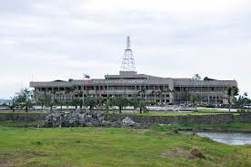
Ilagan City, situated as the provincial capital, is renowned for its rich cultural heritage, natural attractions, and agricultural produce. Historical sites such as the Cathedral of St. Michael the Archangel and the Isabela Provincial Capitol are located in the city. Additionally, scenic spots like the Fuyot Springs National Park and Ilagan Sanctuary enhance its allure. With its blend of history, nature, and modern amenities, Ilagan City emerges as a vibrant destination in the northern part of the Philippines.
Visit the official website and Facebook page of Ilagan:
SANTIAGO CITY
Santiago, situated in the province of Isabela, lies approximately 79 kilometers south of Ilagan, the provincial capital, and 326 kilometers north of Metro Manila. The city occupies a vast, flat, and fertile area in the Cagayan Valley, surrounded by mountain ranges such as the Caraballo Mountains to the south, the Great Sierra Madre to the east, and the Cordillera Mountain Range to the west. Geographically, Santiago spans from 16°35’00” to 16°47’30” north latitude and 121°25’00” to 121°37’00” east longitude.
Despite its southern location within Isabela, Santiago plays a crucial economic role due to its central position within the regional economy. It serves as a pivotal hub connecting various parts of Region 2, enhancing its potential for significant economic growth and development within the provincial network.
Visit the official website and Facebook page of Santiago:

MUNICIPALITIES:
- Alicia
- Angadanan
- Aurora
- Benito Soliven
- Burgos
- Cabagan
- Cabatuan
- Cordon
- Delfin Albano
- Dinapigue
- Divilacan
- Echague
- Gamu
- Jones
- Luna
- Maconacon
- Mallig
- Nanguilian
- Palanan
- Quezon
- Quirino
- Ramon
- Reina Mercedes
- Roxas
- San Agustin
- San Guillermo
- San Isidro
- San Manuel
- San Mariano
- San Mateo
- San Pablo
- Santa Maria
- Santo Tomas
- Tumauini
ALICIA
The municipality of Alicia is one of the thirty-four (34) municipalities and three (3) cities of the Province of Isabela. It lies 54 kilometers south of Ilagan (capital town of the province), through Maharlika Highway and approximately six (6) hours trip at a distance of 347 kilometers from Manila. It is accessible to its neighboring municipalities like Angadanan, Echague, San Isidro, Cauayan, San Mateo and Ramon.
Visit the official website and Facebook page of Alicia:
ANGADANAN
Angadanan is a 3rd class municipality located in the southern Isabela Province. It is bounded on the north by Cauayan City, on the east by Benito Soliven and San Guillermo, on the south by Echague, and on the west by Alicia. It has a total land area of 204 square kilometers and is politically subdivided into 59 barangays.
The town celebrates the Gakit Fluvial Festival.
Visit the official website and Facebook page of Angadanan:
AURORA
Aurora, named for its association with dawn and new beginnings, symbolizes hope, progress, and a gateway to the Mallig Region from the south. Originally a barrio called Dalig under Gamu municipality, it gained status as a Municipal District on August 27, 1927, and today comprises thirty-three barangays. Located in the central-western part of Isabela Province, Aurora is bordered by San Manuel to the north, Burgos to the east, Ifugao province (specifically the municipality of Alfonso Lista) to the west, and Cabatuan to the south. The town is accessible via national and provincial roads from Cabatuan, San Manuel, or Burgos, facilitating its connectivity within the region.
Visit the official Facebook page of Aurora:
BENITO SOLIVEN
The municipality of Benito Soliven is situated nearly at the center of the Province of Isabela. It is bounded on the north by the municipality of Ilagan, the capital town of the province; on the east by the town of San Mariano; on the west by the municipalities of Naguilian and Cauayan City.
Visit the official Facebook page of Benito Soliven:
BURGOS
The creation of Burgos municipality in Isabela marked a significant development for residents in the western part of Gamu, spanning approximately 16 kilometers. One of the thirty-four municipalities and three cities in Isabela, Burgos is situated in the mid-western region with geographic coordinates ranging from 17°08’30” latitude to 121°40’00” to 121°48’00” longitude. It is bordered by Quirino to the north, Gamu to the east, San Manuel and Aurora to the southwest, Roxas to the west, and Luna to the south. Burgos enjoys direct access from three neighboring municipalities: 11 kilometers from Gamu, 13 kilometers from Roxas via asphalt-paved provincial roads, and 16 kilometers from Aurora via graveled provincial roads. Located approximately 25 kilometers south of Ilagan, the provincial capital, Burgos is accessible via a seven and a half-hour trip from Manila.
Visit the official Facebook page of Burgos:

CABAGAN
Cabagan, a 1st class municipality in Isabela with a population of 43,562 people, has historically served as the business center for nearby towns Santa Maria, San Pablo, and Santo Tomas. Renowned for its pancit Cabagan, the town’s well-educated Ybanag residents have produced many top politicians, professionals, and world-class athletes. During Christmas, Cabagan Square Park is brightly illuminated with lights and lanterns. Notable schools include Cabagan Science Elementary School and Isabela State University Science and Technology High School. The town features Malasi Lake, a sanctuary for migratory birds, and the eco-friendly Taguinod Cattle Ranch known for its crops, carabao mangoes, and purebred American Brahman cattle. Cabagan also hosts the largest gymnasium in Isabela and Region 2, and a century-old Spanish-built well at St. Ferdinand College.
Visit the official website and Facebook page of Cabagan:
CABATUAN
The history of Cabatuan traces back to a time when it was lush with forests and teeming with wildlife, nourished by the Magat River. Initially inhabited by the Kalinga tribe, known historically as headhunters, the area saw the arrival of pioneering Ilocano Christians in 1912. Tensions arose between the settlers and the native Kalingas living along the riverbanks, leading to nightly conflicts and raids. To mitigate these hostilities, Bonifacio Bangug, from Piddig, Ilocos Norte, who had lived among the Kalingas, brokered a peace agreement facilitated by Don Bernardo C. Dacuycuy and Infiel Utleg. This agreement fostered friendship and cultural exchange, with Christians sharing goods and converting Kalingas to Christianity. Over time, the settlement’s name evolved from “Ambatuan,” meaning “no stones” in Kalingan, to “Cabatuan,” reflecting the peace that eventually flourished between the communities.
Visit the official website and Facebook page of Cabatuan:
CORDON
The municipality of Cordon is at the southwestern part of the province of Isabela. It bounded on the north by the Municipality of Ramon; East by the city of Santiago; South by the Province of Quirino and West by the Province of Nueva Vizcaya. It lies on Meridians of 121o27’E Longitude and16o40’N Latitude. Cordon has an area of 22,891 hectares unevenly distributed among 26 barangays. This represents 2.14 percent of the total provincial land area.
Visit the official Facebook page of Cordon:
DELFIN ALBANO
Delfin Albano is a 4th class municipality in the province of Isabela, Philippines. The municipality was formerly known as Magsaysay, Isabela. It was named after the former Congressman, Hon. Delfin Albano. According to the latest census, it has a population of 26,614 people in 6,637 households.
Visit the official website and Facebook Page of Delfin Albano:
DINAPIGUE
Dinapigue is located in the southeastern-most part of the province, near the provincial boundaries of Quirino and Aurora. It is bounded in the north by Palanan, in the west by Echague, San Guillermo and San Mariano, and in the south by Aurora Province. It is virtually land locked by Sierra Madre Mountain range on the west and Pacific Ocean in the east.
The municipality is centered approximately in the intersection of geographical coordinates 122 15’40” north latitude and 16 31’45” east longitude. It is one (1) of the five (5) coastal towns of Isabel with its Poblacion situated about 78 kilometers aerial distance from Ilagan, the provincial center of Isabela.
Visit the official Facebook page of Dinapigue:
DIVILACAN
Divilacan, located in Northeastern Isabela, is one of the province’s four coastal municipalities. It is bordered by Maconacon to the north, the Philippine Sea to the east, Tumauini and Ilagan to the west, and Palanan to the south. Initially estimated to cover 120,000 hectares, a 1996 perimeter survey by the municipal government and the Land Management Bureau, DENR Regional Office 02, revised Divilacan’s land area to 89,202 hectares, including a contested 253-hectare area in Barangay Dimapnat.
Visit the official Facebook page of Divilacan:
ECHAGUE
Echague, Isabela is a municipality located in the province of Isabela, Philippines, situated in the Cagayan Valley region. It is known for its agricultural productivity, particularly in rice and corn cultivation. The town also features scenic landscapes, including rolling hills and fertile plains. Echague is home to various cultural and historical landmarks, providing visitors with insights into its heritage and traditions.
Visit the official website and Facebook page of Echague:

GAMU
Gamu, the oldest town in Mallig Plains located in Isabela Province, occupies a central position approximately 10 kilometers from the Provincial Capitol and 395 kilometers from Manila, the capital of the Philippines. It is bordered by Ilagan to the north, Quirino to the northwest, Reina Mercedes to the south, Burgos to the southwest, and Naguilian to the southeast. With a total land area of 129.40 square kilometers, Gamu comprises 16 barangays, including 3 urban barangays (District I, II, and III) and the remaining classified as rural barangays.
Visit the official Facebook page of Gamu Isabela:

JONES
The municipality of Jones is situated in Southern Isabela region. It is bounded on the east and north by Echague, south by San Agustin and partly by Quirino Province and west also by the Province of Qurino. It roughly lies between 12’35’ to 122 degrees east longitude, 16’37 north latitude. It is accessible from the north latitude. It is accessible from the north via Echague little less than 353 linear kilometers from Manila.
Visit the Official website and Facebook page of Jones:

LUNA
MACONACON
Maconacon is a 3rd class municipality in the province of Isabela, Philippines. According to the latest census, it has a population of 4,253 people in 977 households.
Maconacon is politically subdivided into 10 barangays.
Visit the official Facebook page od Maconacon:

MALLIG
Mallig is a landlocked 4th class municipality in the province of Isabela, Philippines. It covers an area of 133.40 square kilometers (51.51 square miles), constituting 1.07% of Isabela’s total land area. The town’s name is derived from the Mallig River, which flows through the municipality. Historically, it was part of the Mallig Plains Resettlement Area, established in 1939 as a resettlement zone for settlers from the Central Plains and the Ilocos Region. Mallig officially became a municipality on April 8, 1953, with Olango as its seat of government. The territory was carved out from several neighboring towns, including Roxas, Ilagan, and Tumauini.
Visit the official Facebook page of Mallig:

NANGUILIAN
Naguilian, a municipality in Isabela, Philippines, is known for its rich history and cultural heritage. Founded in 1896, it’s nestled within the Cagayan Valley region, offering a glimpse into the country’s colonial past. The town boasts diverse geography, from its barangays to its climate, contributing to its unique identity. With a landlocked location, Naguilian serves as a hub of local governance and education, reflecting the vibrant community spirit that characterizes this picturesque area.
PALANAN
Palanan, situated along the Pacific Coast in Isabela, features a Poblacion nestled within a fertile alluvial plain surrounded by distinctive physio-geomorphological formations attributed to volcanic activities and tectonic movements in the Pacific Belt of Fire. The tropical climate brings hot and humid conditions, shaped by northeast and southeast monsoons that create distinct wet and dry seasons and annual typhoons, often damaging crops and property. Despite these natural advantages, Palanan struggles with economic challenges including limited industries, job opportunities, inadequate transportation infrastructure, and a lack of basic socio-economic facilities, hindering its economic growth and physical development. Nevertheless, the town sustains human settlements due to a growing population, maintaining its position as one of Isabela’s coastal towns with coordinates ranging from 122°9’ to 122°32’ East longitude and 16°50” to 17°10’ North latitude.
Visit the official website and Facebook page of Palanan:

QUEZON
Quezon, officially the Municipality of Quezon, is a 4th class municipality in the province of Isabela, Philippines. It serves as a border town between Isabela and the province of Kalinga through the Quezon-Tabuk Road. The city of Tabuk lies to the west of Quezon. The town was named in honor of President Manuel L. Quezon under Republic Act No. 2418, approved on June 21, 1959. Prior to its creation, Quezon was part of a vast agricultural land known as the Mallig Plains and was sparsely populated. Historians believe that its earliest inhabitants were the Igorots and Kalingas from the Cordilleras, as well as the Irrayas.
Visit the official website and Facebook page of Quezon:
QUIRINO
The Municipality of Quirino, officially designated as such, is a 4th class municipality located in the province of Isabela, Philippines. Situated in the Mallig Plains region, Quirino predominantly engages in agriculture. The town boasts extensive flat lands used for cultivating crops such as rice (palay), peanuts, corn, tobacco, and various vegetables. It shares borders with Delfin Albano to the north, Mallig to the northwest, Roxas to the southwest, Burgos and Gamu to the south, and Ilagan City to the east.
Visit the official Facebook page of Quirino:
RAMON
Ramon is situated in Southern Isabela containing an area of 13,517.23 hectares as per actual cadastral survey conducted by the DENR Land Management Bureau. It is bounded on the north by the municipality of San Mateo; on the east by the municipality of Alicia and San Isidro; on the south by the City of Santiago and on the west by Diadi River which serves as the natural boundary between Ramon and Cordon, Isabela. Northwestern part of the municipality is flanked by the mighty Magat River which serves as a natural boundary between Isabela and Ifugao Province.
Visit the official Facebook page of Ramon:

REINA MERCEDES
The Municipality of Reina Mercedes is situated in Central Isabela. It is a satellite municipality of Cauayan, a growth center of the province of Isabela. Its terrain is generally flat rolling. It is bounded on the north by Naguilian; on the east by Cagayan River; on the south by Cauayan; and on the west by Luna. The poblacion is approximately 23 kilometers south of Ilagan on the national highway and 10 kilometers north of Cauayan.
Visit the official Facebook page of Reina Mercedes:

ROXAS
Roxas, Isabela, another municipality in the province of Isabela, Philippines, is renowned for its agricultural productivity. It produces main agricultural products such as rice, corn, and tobacco. The town also hosts various cultural and historical sites, including churches and ancestral houses that showcase its rich heritage. Roxas actively evolves, balancing the preservation of its traditions with fostering economic growth through agriculture and tourism initiatives. Furthermore, the municipality is committed to enhancing its cultural offerings while promoting sustainable development strategies.
Visit the official Facebook page of Roxas:

SAN AGUSTIN
San Agustin is situated at the southernmost part of Isabela containing an area of 27,840 hectares, with 17,230 hectares of Alienable and Disposable Lands and 10.610 hectares of forestlands. The municipality of Jones bound it on the west, south and southeast by Quirino Province and on the north to the northeast by the Municipality of Jones, Isabela.
It is composed of 23 barangays. East of the Cagayan River that bisects the municipality are 14 barangays and on the western side are 9 barangays that include Masaya Centro, the seat of the Municipal Government.
Visit the official Facebook page of San Agustin:
SAN GUILLERMO
San Guillermo operates as a 4th class municipality in the province of Isabela, Philippines. It derives its name from Eugenio Guillermo, a former mayor of Angadanan. Established on June 17, 1967, under Republic Act No. 4906, sponsored by Melanio Singson, the then-representative of Isabela’s lone district. San Guillermo comprises 26 barangays, each contributing uniquely to its vibrant community. The municipality sustains its economy through agriculture, fisheries, and tourism, fostering growth and opportunity across its diverse sectors.
Visit the official website and Facebook page of San Guillermo:

SAN ISIDRO
San Isidro, Isabela, is a municipality that embodies rural tranquility and agricultural prosperity. Established in 1967, it stands as a place where the community thrives amidst the lush landscapes of the Cagayan Valley. The town comprises 13 barangays, each contributing to a strong sense of unity and local culture. San Isidro’s dedication to progress shines through its infrastructure and governance, positioning it as a beacon of development in the region.
Visit the official Facebook page of San Isidro:
SAN MANUEL
San Manuel, formerly known as Callang, is a 4th class municipality in the province of Isabela, Philippines. It lies within the Cagayan Valley region and is situated along the Cagayan River. The town has a rich historical background, having been founded in the mid-18th century as a settlement in present-day Nueva Vizcaya. Originally located between the towns of Bagabag and Bayombong, it was later moved north to its current location in Isabela province. This relocation facilitated better transportation links and provided security against raids by the Igorots and Gaddangs.
Visit the official Facebook page of San Manuel:
SAN MARIANO
San Mariano, recognized as the largest town in the Philippines, covers a vast land area of 146,950 hectares, constituting 13.78 percent of Isabela Province’s total land area. Situated in the eastern part of Isabela, it is bordered by Ilagan to the north, Palanan to the east, San Guillermo to the south, and Benito Soliven to the west. Approximately 404 kilometers from Metro Manila and 46 kilometers from Ilagan, the provincial capital, San Mariano’s geographic coordinates range from approximately 16°57’41” to 17°00’08” north latitude and 121°58’39” to 122°01’20” east longitude.
Visit the official website and Facebook page of San Mariano:
SAN MATEO
In what life was crude and simple, San Mateo has developed into one of the progressive towns of Isabela. First named as “Marasat”, it was a former barangay of Cauayan, then Santiago. It was called the Municipality of Yoshisawa under the government of the Japanese Imperial Army during the Second World War. After the liberation, it was finally created and named San Mateo by virtue of Presidential Executive Order No. 97 on March 17, 1946, by former President Sergio Osmeña. It was proclaimed as the Agro–Ecological Destination in Cagayan Valleyby President Gloria Macapagal Arroyo by virtue of Presidential Proclamation No. 1685 dated December 1, 2008.
Visit the official Facebook page of San Mateo:
SAN PABLO
San Pablo is a 2nd class municipality in the province of Isabela, Philippines. According to the latest census, it has a population of 25,384 people in 5,134 households.
San Pablo is politically subdivided into 17 barangays.
Visit the official Facebook page of San Pablo:
SANTA MARIA
The municipality of Sta. Maria, Isabela is located in the interior northwestern part of the province of Isabela. It is bounded on the north by the municipality of Enrile, Cagayan and on the East of Cagayan River which the natural boundary between Cabagan, Isabela and on the west of Kalinga Province. It is more or less 65 kilometers away from Ilagan, capital town of Isabela. Sta. Maria is also accessible via Tuguegarao, Cagayan with a half-cemented and half-graveled road. An alternate route to reach Sta. Maria is by passing through Quezon, Isabela with a more convenient cemented road of about 39 kilometers.
Visit the official Facebook Page of Sata Maria:
SANTO TOMAS
Santo Tomas is a 4th class municipality in the province of Isabela, Philippines. According to the latest census, it has a population of 23,005 people in 4,980 households.
Visit the official Facebook page of Santo Tomas:
TUMAUINI
Tumauini, a first-class municipality in Isabela, Philippines, is home to approximately 67,650 residents distributed across 46 barangays. Its notable landmark, the Tumauini Church, built in the 1870s by the Dominicans, features a distinctive cylindrical brick bell tower. The town also attracts visitors to Camp Samal Resort and Leisure Park, offering panoramic views of the town and the Cordillera Sierra Madre Mountain range. Despite its tranquil atmosphere, commercial activities mainly center around a local market selling a variety of goods including fruits, vegetables, meats, and entertainment items like VCDs and firecrackers.
Visit the official Facebook page of Tumauini: